


Es kann frustrierend sein. Eine weite Anreise an den Spot in freudiger Erwartung und vor Ort bewegt sich kein Blatt. Die Vorhersage war allerdings nicht eindeutig und beim losfahren warst du schon nicht sicher. Als Kitesurfer sind wir vor allem von Wind und Wetter abhängig. Eine normale Wetter-App reicht da meistens nicht aus und wir brauchen mehrere Infos über Windstärke und Windrichtung, Temperatur und Luftdruck um unser Hobby ausüben zu können.
In this blog I explain where we check the wind and how you can read the models correctly. In truth, experience at the “home spot”, gut feeling and good old hope play a big role.
Of course, you can always contact us if you are not sure. We are happy to share our experience and help you get to the spot well.

Forecast models - how do they work?
Forecasts are nothing more than mathematical calculation models into which a large amount of measurement data flows (data from weather stations, airplanes, satellites ...). An equation is used to calculate a later weather condition from the atmosphere, in which variables such as air pressure, temperature and density play an important physical role. If any of these variables change, the forecast changes and the data in the apps is updated.
Global vs. Local models:
There are several forecast models / weather maps such as: GFS, WRF, ECMWF, NEMS, ICON, and many more. For the models, a grid is placed over the globe (global models) or a specific region (local models) . Depending on the model, this grid changes size (e.g. GFS = 13km, ICON = 7km). For topographical reasons, models can work differently well and precisely - GFS works well in coastal regions without major obstacles, such as mountains. Here at the lake, models with a smaller grid system are often more accurate. It is therefore always worthwhile to compare several predictions . The smaller the grid, the more data flows into the calculation system. So it takes a huge amount of data to calculate wind and weather, and only so-called “supercomputers” can do this nowadays.
Why can the weather forecasts show different forecasts?
If, for example: a local model with a small grid does not yet have a creeping low pressure area on the "radar", it may be that the "global model" (due to the larger grid) already shows the wind and the other only learns about it later. So exactly when the low pressure area is also displayed in the smaller grid.
Of course, it is best if all models announce the wind. Then the probability is very high that you can exercise them. There are also predictive models that show the average of all models.
Have you ever heard of the so-called "butterfly effect"? Small changes can have a big impact. So the butterfly in Canada can flap its wings and we in Austria, Germany and Switzerland have perfect wind of 27 knots for 4 days.
Then why aren't there just global models to perceive every change? Wouldn't the forecast then be more accurate because every change is factored in? The answer: probably yes, but the calculation and the amount of data would require even greater computing capacity. Of course, this is also associated with high costs. If you were to import all the data with a small grid across the globe into the supercomputer, you would have the result of the calculation after the onset of weather. So it doesn't bring much.
Weather maps:
The different models (see above) are operated by different states or weather services : there are American weather models and also some from and for Europe. And of course also B calculation models from e.g .: Germany. One can assume that, for example: the calculation models from Europe (eg: ECMWF - European Center for Medium-Range Weather Forecasts) are better suited to our regions. You can browse the respective pages of the weather services on the Internet here, you will definitely find some interesting topics.
Wind directions
Of course, not all wind directions work on all spots. Here you should inform yourself in advance about the conditions at the spot. Wind directions are very important and often linked to local conditions, which you only have gradually as information or when you talk to the local kitesurfers (if they want to share their knowledge). It may be that the forecast shows 4 knots, but sunshine and the right direction (e.g. at thermal spots ). The bars on the spot are happy and you plan an alternative program.
What is meant by that? That you should not only orient yourself on the wind force in the weather forecast . Pay attention to the direction, tendencies, temperatures, air pressure, sunshine and clouds.
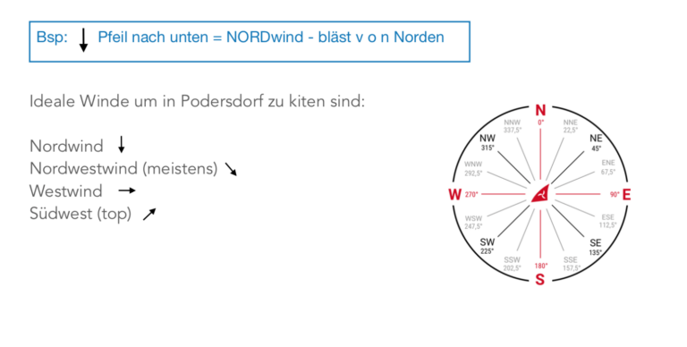
For the kitesurfers in Podersdorf: , for example: an east or north-east wind is rather useless here and luckily only very rarely. But north wind is very funny. The weather app says wind on most of the kiters start, as they are used to from the main wind direction northwest. And forget that the north wind means that a large area on the beach is covered by wind. Wrong starting positions and too big kites as a result. The wind direction is not to be neglected.
What is missing in this figure is the southeast wind and above all the south wind . These can also be used well in Podersdorf if the basic wind is not too low. Most of all, it is associated with sunny, hot temperatures. Tip at the edge: always pay attention to the "east impact" in the forecast. Too much east means gusty and “bitchy”, or it doesn't really get through.
Pages and Apps
Here is a small overview of the most common and popular sites and apps for kitesurfers. Of course: Experience at the respective spots plays a major role. There have been great predictions, but no wind. Likewise vice versa. This happens, which is why “never trust the weather forecast” often applies. I have to admit, I use different pages in different spots. For example, I like the Windguru best in Podersdorf and I use the Windfinder more often in Hamata / Egypt. I do not know why either.
Windguru.cz
In Windguru, forecasts are presented in tables based on the weather models. At a glance, you can get a lot of useful data quickly and easily in 1-2 hour steps.
In the app you can search for the spot at the top left (in our case “Austria - Podersdorf Kitestrand or“ Austria Neusiedler See ”).
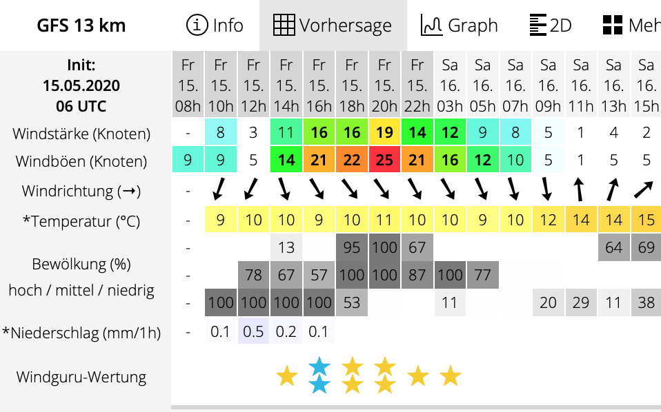
Each table shows a different calculation model, whereby in the first table (WG) all forecasts are mixed and the average calculated from them is displayed. Data that can be read from the tables are wind strength, wind gusts, wind direction, temperature, cloud cover and precipitation. The stars at the bottom are a rating from Windguru, but they don't have to match your personal assessment. deiner persönlichen Einschätzung übereinstimmen muss.
* = could work ** = very good wind *** = great wind
If blue stars are shown, cold weather (standard ≤ 10 ° C) is expected and the same rating applies.
At spots where you find tides and waves, the "tide times" of high and low water, the "wave height", "wave period" and "wave direction" are also displayed. However, this is a separate and yet complex topic.
Windfinder.com
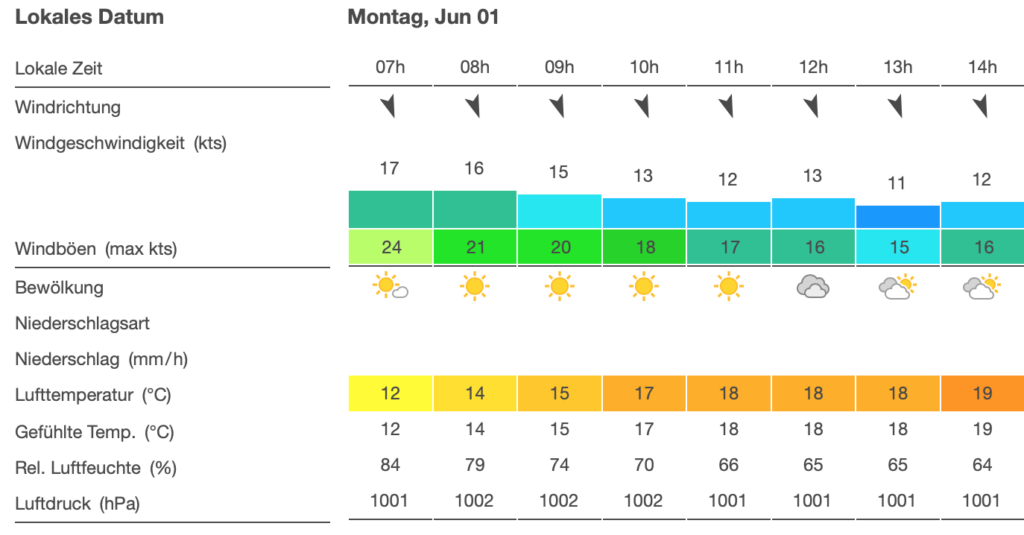
Windfinder is very simple and clear and is also based on the GFS model. On Windfinder you can choose not only the normal forecast but also the Superforecast. In the forecast, the horizontal resolution is approx. 13 km and you get wind values in 3-hour steps for the following 9 days. In the Superforecast the grid is approx. 7 km and there are hourly values for the next 2 days.
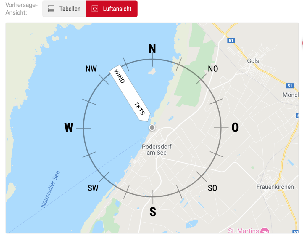
In the “aerial view” display, a compass rose shows exactly from which direction the wind is coming and also reads out some data.
In the menu item Map you will find an interactive map that shows the wind speed depending on the strength (kn) in different colors.
As with every page or app, you can personalize i in the settings by e.g. can choose between different measuring units (Beaufort, knots, km / h ...).
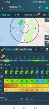
windy.app und windy.com
These two apps or pages visualize the wind. So you can have the wind direction and wind strength displayed on the map at every spot in the world. It's also really funny to see where there is how much wind. Cyclones or storms are also pretty easy to spot. The advantage of this visual representation: you can immediately see how the respective wind is to be found at the spot (onshore, offshore, sideshore, etc.).
The free windy.app app provides a modern menu with lots of information and a large spot database.
The built-in spot chat is a particular feature of the app, where you can get tips and information about the current conditions from locals, or arrange to meet up for joint sporting activities.
What can be particularly helpful for beginners - if you personalize the app, in addition to the wind data, suitable kite sizes are suggested for you. But please act with caution here, because there are also spots where, in addition to the popular wind, there is, for example, thermals. Then the calculated 12 kite can quickly become too big.
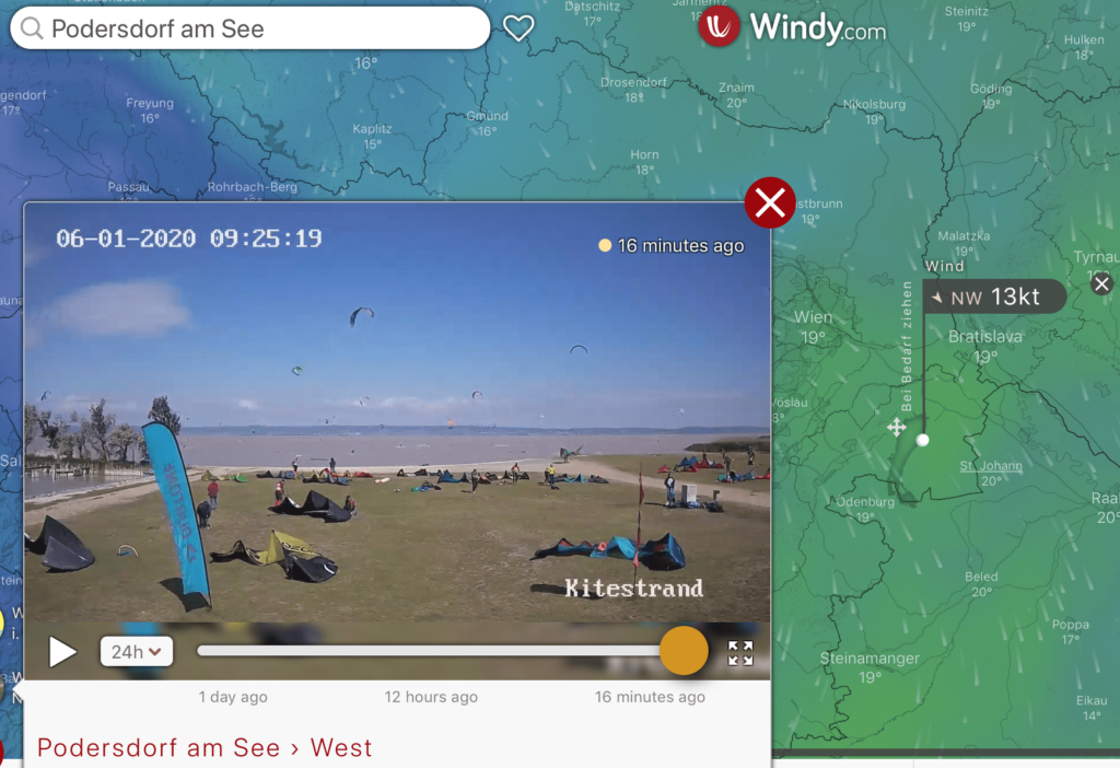
Windy.com has received awards over and over again in recent years and is now also a topic in the forecast of hurricanes, etc. Here you can get a lot of different information. Also display thunderstorm cells etc.
What I like about the free windy.com app is, in addition to the interactive map, which can be set individually, the web cam function. So you can check directly on the app what the kite spot looks like right now.
Of course, this list of wind and weather sites or apps is by no means complete. There are many sites where you can get predictions. There are also weather calculations and pages for individual spots that work well. This then differs from spot to spot.
Conclusion:
In the end, these are still predictions, not facts. You can find out what it really is like at the spot by being present. The following applies: the more the different calculation models agree, the more likely the forecast is. If the different predictions do not agree, there are the following options: experience , pay closer attention to detail or simply take the forecast that seems best to you.
Most of the time you can find your way of dealing with forecasts. It is important to us: read between the lines, ask local restaurants and don't just pay attention to the wind speed in the forecast.
Yes, it can be complicated and tedious.
Our recommendation: deal a little every day with the local conditions and the forecasts. Constants can be recognized. This will give you experience and thus more kite sessions on the water.
As already mentioned in the introduction, you can contact us at any time and we will be happy to help you should you need more information about various spots.
Don't miss anything!
We'd love to write to you
We only send our newsletter when we actually have something to say, word of honor. Useful information for kiters and everyone who wants to become one, tips, tricks and howtos, honest reviews and special offers. Just try it out!